ARADCOM

Detroit - Cleveland
Defense Area
ARADCOM |
|
Detroit - Cleveland Defense Area |
| Unit: | 6/57 - 9/58, HHB, 18th USA 6/57 - 9/58, Battery B, 18th USA 9/58 - 12/60, HHB, 4th Battalion, 3rd USA 9/58 - 10/60 Battery B, 4th Battalion, 3rd USA 10/60 - 2/63, Battery A, 2nd Battalion, 177th MIARNG |
| Activation Date: | June 1957 |
| De-activation Date: | February 1963 |
| IFC Area: |
North side of 11 Mile road between Franklin and Center road. |
| Launch Area: | North side of 11 Mile road between Telegraph and Inkster roads. GPS: +42° 29' 21", -83° 18' 24" |
| Radar(s): | LOPAR |
| Missiles: | 30 Ajax |
| Magazine(s): | 1 type B, 2 type C |
| Launchers: | 12 Ajax |
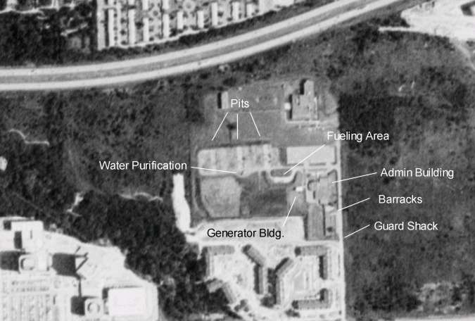
| Current Status: | The IFC has been demolished. Site is now the location of a couple of office buildings. The Launcher area is partially intact. It resides within an Army Reserve facility. The Fueling Berm is still there but the building is gone. There is another building outside of the berm which I can't identify but could be the Generator Building. The Barracks and the Admin building have been converted to use first by the Naval Reserve (I drilled there and did not even realize what the site was) and now by the Army Reserve. The water purification building and a tank still remain along with all 3 pits which have filled with water. |
| Comments: | Updated IFC information was provided by Mike Denja. |

D-86 IFC as seen in 1963. Contributed by Mike Denja.

D-86 Launcher Area as seen in 1963. Contributed by Mike Denja.

D-86 as seen in 1967. The road to the South is Eleven Mile Rd. The road to the east of the IFC is Franklin Rd.

D-86 Launcher Area as seen in 1967.

D-86 IFC as seen in 1967. The road to the south is Eleven Mile Rd.

This image was taken on 6 June 1988. Here is the Launcher Area as it was in 1988.
This page was last updated on
16-Jun-2018
.
© 1998 - 2025 T. Bateman